
Penthièvre Isthmus & Wild Coast – Mineral Splendor of Quiberon
The Penthièvre isthmus and the Côte Sauvage form an exceptional geographical duo with striking contrasts. A tombolo just 22 meters wide connects the Quiberon peninsula (15 km long) to the mainland, facing 8 kilometers of steep granite cliffs lashed bythe raging Atlantic. Protected natural areas managed by the Conservatoire du Littoral, free access all year round. Marine erosion has sculpted natural arches (the fragilePort-Blanc Arch ), wild coves and spectacular panoramas. 8 km of marked coastal paths (2-3 hour hike), V5 greenway for bikes, 18th-century Fort de Penthièvre, 1904 Anglo-medieval Château Turpault. Just 10-20 minutes from Camping Les Druides, enjoy an invigorating experience facing the raw power of Brittany's coastal nature.
📌 About This Natural Area
Camping Les Druides recommends the Isthmus and the Côte Sauvage via its blog and recommendation articles.
Important: The Penthièvre Isthmus and the Côte Sauvage are protected natural areas that are freely accessible and managed by the Conservatoire du Littoral and the municipalities of Saint-Pierre-Quiberon and Quiberon. Les Druides campground:
does not manage these spaces
does not offer guided tours
simply facilitates your access to these remarkable spaces
We recommend these exceptional sites to enrich your stay.
For practical information—access conditions, tide times, marked trails— contact the Quiberon Bay Tourist Office.

🌊 The Isthmus of Penthièvre – The Mythical Tombolo
Unique Geography & Geology
The Penthièvre isthmus, known as a tombolo, is a natural wonder:
Length: Approximately 7 kilometers
Minimum width: Only 22 meters at its narrowest point
Formation: Sand spit built up by ocean currents over thousands of years
Composition: Fine sand and sedimentary deposits
Function: Connects the Quiberon peninsula (formerly an island) to the mainland
Remarkable feature: The Quiberon peninsula is 15 kilometers long, but only 22 meters wide at its narrowest point!
Spectacular Contrast of Waters
Unique panorama:
✅ To the east: Quiberon Bay – Calm waters, sheltered from prevailing winds
✅ To the west: Atlantic Ocean – Powerful swells, wild and untamed coastline
At the isthmus, you can gaze upon two diametrically opposed seas from the same spot!
Vital Strategic Passage
22 meters combining road, railroad tracks, and bike path:
Route D768: Only road access to Quiberon
Tire-Bouchon railway line: History of the Auray-Quiberon line (1882)
V5 bike path: Secure Erdeven-Quiberon greenway (since 2019)
Risk: During storms, road submerged by seawater
Historical consolidation: Les Ponts et Chaussées (1870) and then the Compagnie d'Orléans (1882) reinforced this isthmus for the passage of roads and railways.
Fort of Penthièvre – Military Heritage
Iconic defensive fortification:
Construction: Decided in 1747 under the Duke of Penthièvre, governor of Brittany
Reason: Following the plundering of 1746 by the English
Architecture: Imposing military structure dominating the isthmus on the "La Palice" escarpment
Military history: Royalist siege in 1795 (4 days), modernized in 1800 (Marescot), German prison in 1917, current military training base
Visit: Exterior possible, crypt and memorial accessible
Panoramic view: Exceptional view of the wild coast and Quiberon Bay
🏔️ The Wild Coast – Grand Geological Theater
General Features
The Côte Sauvage, one of Brittany's most beautiful coastlines:
Length: 8 kilometers from Château Turpault to Pointe du Percho
Orientation: Due west, facing directly onto the Atlantic Ocean
Geology: Granite cliffs, sometimes over 20 meters high
Ownership: Conservatoire du Littoral (strict national protection)
Erosion: Permanent and spectacular
Formation by Marine Erosion
The ocean, architect of the Côte Sauvage:
✅ Cliffs shaped by thousands of years of waves and wind
✅ Rock arches carved out by sea water infiltration
✅ Wild coves formed by differential erosion
✅ Caves accessible at low tide
✅ Pierced rocks – ancient geological formations
Remarkable Coastal Flora
Dunes perched on cliffs:
Sea pink: Small pink flowers with symbolic meaning
Maritime armory: Typical Breton pink flower
Natural lawn: Short grass resistant to wind
Halophilic vegetation: Adapted to salt spray
🏔️ Remarkable Sites on the Côte Sauvage
Pointe du Percho – Exceptional Viewpoint
Mythical promontory on the coast:
Features:
Military remains: Former watchtower/customs post
Panoramic view: Spectacular view of cliffs and ocean
Accessible: On foot via marked coastal trail
Points of interest: Perfect for photos of sunsets and sunrises
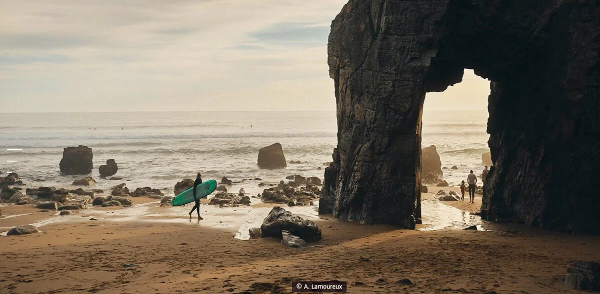
The Port-Blanc Arch – Roche Percée
A natural gem shaped by marine erosion:
Geological wonder:
Massive granite arch eroded by water
Accessibility: Visible from the trail overlooking
Low tide: Only access possible from the neighboring beach
Light show: At sunset, the arch is enhanced by the light shining through it.
Condition & Conservation:
⚠️ Increasing fragility: Successive storms and runoff are continuously eroding the site
⚠️ Restricted access: Since winter 2020, the cliff staircase has been closed (danger of rockfalls)
⚠️ Uncertain lifespan: Will the arch hold? "At the beginning of the century, there were two arches."
Symbol: The rainbow represents the raw power of nature and fleeting beauty.
Château Turpault – Emblem of the Wild Coast
Historic manor house marking the entrance to the coast:
Architecture & History:
Style: Picturesque Anglo-medieval
Construction: 1904-1910 by contractor Hippolyte Jamet
Designer: Georges Turpault, spinner from Cholet
Original name: "Château de la Mer" (renamed "Château Turpault")
Location: Pointe de Beg er Lann ("Pointe de la Lande" in Breton)
WWII history: Occupied by the German army from 1940 to 1945, two blockhouses built
Ownership: Private – Exterior viewing only
Spectacular view: The castle offers a magnificent panorama of the coast and Belle-Île-en-Mer in the distance. Emblem photographed on postcards, star of international films and advertisements.
Other Coastal Points of Interest
Traveling along the Wild Coast:
✅ Ancien Vivier: Historic fishing facility
✅ Trou du Souffleur: Sea cave with acoustic phenomenon
✅ Fontaine de Port Kerné: Natural coastal spring
✅ Pointe de Kervihan: Neolithic camp (visible fortifications)
✅ Port Bara: Coves with caves accessible at low tide, surfing spot
✅ Port Blanc Beach: Fine sand with iconic arch view
✅ Pointe de Beg en Aud: Venetian camp (Gallic period)
✅ Crique de la Vierge: Small wild rocky beach

🚶🚴 Explore the Isthmus & the Wild Coast
On Foot – Marked Trails
8 kilometers of coastal walking trails:
Markings: Red and white on the coast, yellow inland
Difficulty: Easy to moderate (rocky terrain)
Duration: 2-3 hours depending on pace
Departure: Château Turpault or Pointe du Percho
Parking: Numerous parking areas along the coast (free)
Water points: Port Kerné fountain
By Bike – Greenway V5
Secure bike path along the coast:
Total distance: 23.5-30 km (Erdeven-Quiberon)
Type: Hybrid or mountain bikes recommended (sandy sections)
Surface: Asphalt + sandy paths
Level: Easy – family
View: Spectacular view of the western Côte Sauvage
Water Sports – Isthme Penthièvre (Beach)
Quiberon Bay protected beach:
✅ Sand yachting: Wind sports
✅ Paddleboarding: Calm bay on the east side
✅ Bodyboarding: Small sheltered waves
⚠️ Safety & Essential Recommendations
Danger Swimming Côte Sauvage
The beaches of the Côte Sauvage are NOT suitable for swimming:
⚠️ Undercurrents: Dangerous currents even in calm weather
⚠️ Steep cliffs: Rockfalls possible
⚠️ Prohibitions: Signs prohibiting swimming everywhere
✅ Observation only: Admire from the marked trail
Weather Conditions
Coastline exposed to harsh elements:
Prevailing winds: Strong westerlies
Storm gusts: Very violent in winter
Waves: Water splashing onto Route D768
Prevention: Check the weather forecast before visiting.
Hiking Tips
🏔️ Clothing: Waterproof & windproof clothing required
🏔️ Footwear: Good traction (rocky terrain)
🏔️ Hydration: Water & snacks (few water sources)
🏔️ Low tide: Check times for access to coves/Arch
🏔️ Safety: Stay on marked trails at all times

🏕️ From Les Druides Campground
Very easy access to the isthmus and the Côte Sauvage:
✅ Distance: 10-15 km Penthièvre isthmus
✅ Easy route: 10-20 minutes by car
✅ Free parking: In the immediate vicinity
✅ Heated pool: Afternoon relaxation
✅ Le Carpe Diem bar: Post-hike recovery
Perfect day trip: Morning on the Côte Sauvage (2-3 hour hike) → Picnic lunch → Relaxing by the campground pool! 🏔️
✨ In Summary
The Penthièvre isthmus and the Côte Sauvage embody the raw power and timeless beauty of coastal Brittany. The geographical focal point of the unique 22-meter tombolo, the fragile Arche de Port-Blanc shaped by erosion, 8 kilometers of rugged granite cliffs, invigorating coastal paths, and spectacular panoramic views: this place offers an incomparable sensory and mineral experience.
Historic military heritage (Fort Penthièvre 1747, Château Turpault 1904), remarkable coastal biodiversity, exceptional geological formations continuously transformed by nature, free access all year round: an encounter with the raging Atlantic.
Just a 10-20 minute drive from Camping Les Druides, discover this Breton geological wonder that reminds us of the grandeur of nature and the fragile transience of rock formations faced with the relentless assaults of the ocean.
📞 Contacts & Information
Protected natural areas with free access Conservatoire du Littoral (Coastal Conservation Agency) & municipalities.
For access conditions, marked trails, and tide times, please consult the Quiberon Bay Tourist Office.
Quiberon Bay Tourist Office
Address: 14 rue de Verdun, 56170 Quiberon
Telephone: 02 97 50 07 84
Website: www.baiedequiberon.bzh
Services:
Trail access information
Access conditions, tide times
Detailed marked trails
Updated safety warnings
Coastal Conservation Agency
Website: www.conservatoire-du-littoral.fr
Management: Wild Coast & protected coastal areas
Services: Natural heritage, regulations, environmental protection
Municipalities
Saint-Pierre-Quiberon Town Hall: saint-pierre-quiberon.fr
Quiberon Town Hall: ville-quiberon.fr
Tide Information
Services: Consult official tide tables before visiting Arche Port-Blanc
Websites: www.shom.fr, www.maree.info
Les Druides Campground
Address: 55 Chemin de Beaumer, 56340 Carnac
Telephone: +33 (0)2 97 52 08 18
Website: www.camping-les-druides.com
Distance: 10-15 km from the Penthièvre isthmus
Services: Heated swimming pool, Le Carpe Diem bar, visitor information, hiking advice